
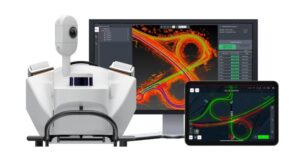
Mobile Mapping Systems
Leica Mobile Mapping Systems
Capture precise 3D data of roads, infrastructure, and urban environments with Leica Geosystems mobile mapping solutions.
Leica Pegasus TRK300
Lightweight and powerful mobile mapping system with AI-assisted features for comprehensive data capture.
- Modular hardware design for expandable applications
- AI-powered image processing for enhanced accuracy
- Lightweight and easy to mount
- Ideal for infrastructure and city planning
- Compatible with Leica Cyclone software for seamless processing
Leica Pegasus TRK100
The lightest mobile mapping system by Leica, perfect for capturing assets and urban infrastructure.
- Single-person operation for easy handling
- Expandable camera systems for versatile applications
- 24-hour continuous operation on a single battery
- Compatible with Leica Pegasus FIELD software for autonomous data capture
- Ideal for asset management and urban mapping
Leica Pegasus TRK Evo
High-precision mobile mapping system for engineering, structural analysis, and rail surveying.
- Advanced sensor fusion for precise data capture
- Modular design for customizable configurations
- Ideal for demanding surveying projects
- Compatible with Leica Cyclone software for seamless processing
- Optimized for rail infrastructure and engineering applications
Leica Pegasus TRK Neo
Versatile mobile mapping system with long-range capabilities and user-friendly operation for precise geospatial data.
- Long-range mapping for comprehensive data capture
- AI-powered image processing for enhanced accuracy
- Modular design for customizable configurations
- Compatible with Leica Cyclone software for seamless processing
- Ideal for infrastructure and urban planning