
Leica Detection Systems
Discover Leica Geosystems’ advanced detection solutions, including utility detection radar, cable locators, and concrete scanners, designed for accurate and efficient subsurface mapping and analysis.
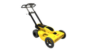
Leica DS4000 Utility Detection Radar
Advanced dual-antenna ground penetrating radar system for efficient and precise subsurface scanning, offering enhanced depth penetration and real-time data visualization.
- Operates across an 80–1500 MHz frequency range
- 30% greater depth penetration compared to previous systems
- Lightweight and portable design for easy field use
- Seamless integration with Leica software for data processing
Leica DSX Utility Detection Solution
Portable ground penetrating radar system with intuitive software, allowing users to easily locate, visualize, and map underground utilities in real-time.
- Smart algorithm for accurate 3D utility mapping
- Real-time data visualization on a tablet interface
- Optional integration with GPS/GNSS for precise georeferencing
- Export data in PDF and DXF formats for seamless reporting
Leica DD100 Series Locators
Electromagnetic locators designed for accurate detection of underground utilities, featuring automated pinpointing and enhanced signal processing for reliable results.
- Automated pinpointing process for improved accuracy
- Multiple operating modes to suit various detection scenarios
- Lightweight and ergonomic design for ease of use
- Compatible with Leica transmitters for extended detection capabilities
Leica C-thrue Concrete Scanner
All-in-one ground penetrating radar system for accurate scanning and real-time analysis of concrete structures, detecting rebars, voids, and other embedded objects.
- Dual polarization for detection of both shallow and deep targets
- Augmented reality visualization for enhanced data interpretation
- Real-time data processing with multi-touch display
- Portable and robust design suitable for various construction sites